W4FAR Repeaters (CTCSS 94.8) VHF:145.37 MHz (-); UHF: 443.55 MHz (+); DMR: 440.5375 (+)
NWS BLACKSBURG SKYWARN® 
NWS BLACKSBURG SKYWARN® ACTIVATION
Blacksburg SKYWARN® is Activated for:
- Severe Thunderstorm and Tornado Watches
- Severe Thunderstorm and Tornado Warnings
- Flood Warning (if not already activated for a Flood Watch)
- Winter Storm Watches and Warnings (at discretion of NWS)
Activation of SKYWARN® is Initiated in Several Different Ways:
Direct phone contact with the appropriate contact people by NWS to activate the system.
The system can automatically activate via weather spotters activation in the following cases:
- Severe T-Storm Watch/Warning
- Tornado Watch/Warning
- High Wind Warning
- Winter Storm/Blizzard Warning
- Flash Flood Watch/Warning
- Ice Storm Warning
- Winter Weather Watch/Warning
ACTIVATION GUIDELINES
When a Severe Thunderstorm, Tornado, or Flood WATCH is Issued
This means severe weather is possible i.e. tornadoes, large hail, dangerous lightning and damaging thunderstorm winds. It is not yet occurring in the area and is usually in effect for a large area of many different counties. The net activates and stands-by to relay information from the NWS to the amateur radio community. As storms develop... amateur radio operators will relay reports to NWS - Blacksburg.
When a Severe Thunderstorm, Tornado, or Flood WARNING is Issued
This means severe weather is imminent or occurring... and is usually issued for one or two counties at a time and lasts for 1-2 hours. This requires a directed... formal County net with reports feeding in from Liaison Stations to the NWS.
When a High Wind, Winter Storm, Ice Storm, or Blizzard WARNING is Issued (and in some cases Winter Weather Advisories)
System activates upon request from the NWS for information such as:
- Snowfall
- Icing
- Wind
- Rainfall
- Rain / ice / snow line
and of course any damage reports.
Reporting to Skywarn®
Contact the National Weather Service at:
- 1-800-221-2856 (For Severe Weather Reports) 1-540-552-0084 (non-severe weather information)
- Amateur Radio (Skywarn® Frequency List below)
- E-mail: rnk.skywarn@noaa.gov (used for delayed reports or non-time critical events like snowfall totals)
- Facebook (http://www.fb.com/NWSBlacksburg)
- Internet: http://www.srh.noaa.gov/StormReport_new/SubmitReport.php?site=rnk
Identify Yourself as a SKYWARN® spotter:
- “I am a SKYWARN® spotter”
Provide Your location:
- An exact address: “1750 Forecast Drive, Blacksburg, VA” B. If mobile, the nearest intersection: “Forecast Drive and Tech Center Drive”
What to Report:
- Tornadoes
- Funnel Clouds
- ROTATING wall clouds
- Flash flooding
- Creeks or streams out of their banks
- Water flowing over a road/roads closed due to flood waters
- One inch of rain or more in less than one hour
- Damage, injuries, or loss of life and/or property caused by flooding, wind, hail, and tornadoes
- Trees, power lines or tree limbs 4” in diameter or larger downed by winds
- 50 MPH wind gusts or higher (measured or estimated)
- Hail (any size)
- Snow 1” in depth”, 4” in depth and the total snowfall when the snow has ended. Provide the length of time the snow fell
- Ice that begins to accumulate on roads and when it accumulates to ¼”
Time:
- Time of the event
- Duration of the event
Area Skywarn® Frequencies
| Boone Skywarn® | Blacksburg Skywarn® | Triad Skywarn® | Charlotte Area Skywarn® |
| 147.360+ (PL 103.5) | 145.130- (PL 103.5) | 147.255+ (PL 82.5) | 145.230- (PL 118.8) |
| 147.300+ (PL 103.5) | 145.350- |
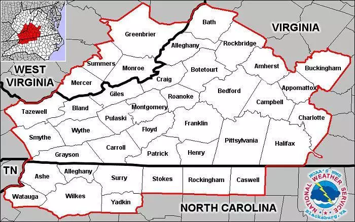
NWS BLACKSBURG SKYWARN® COVERAGE AREA

